Saturday, March 7, 2020

Go visit the Pont du Gard if for no other reason, this "masterpiece" has been standing for 2000 years!

Our favorite Roman ruin in the South of France is the Pont du Gard, the aqueduct bridge that crosses the Gardon River about 60 km (37 miles) from our house in Sablet, between the towns of Remoulins and Uzès.

The Pont du Gard is part of a 50 km (31 mile) aqueduct constructed by the Romans in the middle of the 1st century to bring fresh water from the Eure spring near Uzès, to the Roman city of Nîmes where it supplied running water to fountains, baths and private homes around the city.

The Pont du Gard has three tiers of arches; It is 274 meters (899 ft) in length and stands at a height of 48.8 m (160 ft). Its width varies from 9 m (30 ft) at the bottom to 3 m (9.8 ft) at the top. The three levels of arches are recessed, with the main piers in line one above another.

As you walk out to the Pont du Gard, look for the ancient olive trees on the Left Bank along the path from the Visitor Center. The plaque by one of the trees says it was born in 908 and lived in Spain till 1985 when the Counsel General of the Gard adopted the tree and planted it here in 1988.

1,000 year old Olive tree near the Pont du Gard

Make sure you check out the construction of the bridge, take in the view up or down the river valley, wander across to the far side, explore down along the river and climb up the steps to the upper trail where you have great views of the bridge and surrounding area.

Pont du Gard

The Pont du Gard was constructed largely without the use of mortar or clamps. Most of the stones were extracted from the Estel quarry located approximately 700 meters (2,300 ft) downstream, on the banks of the Gardon River. The stones were cut to fit perfectly together by friction and gravity, eliminating the need for mortar.

The builders left inscriptions on the stonework conveying various messages and instructions. Many blocks were numbered and inscribed with the required locations, such as fronte dextra or fronte sinistra (front right or front left), to guide the builders

Underside of Pont du Gard archway with Roman Numeral placement markings

Shirley at Pont du Gard

The straight-line distance from the spring near Uzès to the town of Nîmes is only about 20 km (12 mi), but the mostly underground aqueduct was built along a winding route measuring around 50 km (31 mi) to circumvent the southernmost foothills of the Massif Central, known as the Garrigues de Nîmes. This was the only practical way to transport water from the spring to the town.

Pont du Gard from right bank of Gardon River

The Romans needed a way to get the water that would flow through the aqueduct across the Gardon River so they built the Pont du Gard with a water channel to complete the aqueduct and get water to its destination in Nîmes.

A view of the Pont du Gard from the left bank of the Gardon River

It is estimated that the aqueduct supplied Nîmes with around 40,000 cubic meters (8,800,000 imp gal) of water a day that took nearly 27 hours to flow from the spring to the town.

A view of the water channel at the top of the Pont du Gard from the left bank of the Gardon River

As I noted earlier, the Pont du Gard was built to carry water from the aqueduct across the Gardon River. Several of the River's tributaries are also called Gardon. The Gardon River rises in the Cévennes mountain range and flows for 133 km into the Rhône River at Beaucaire, from where it flows into the Mediterranean Sea.

View of the Gardon River towards Uzès from Pont du Gard

The Pont du Gard is one of the most popular tourist attractions in France and is open all year round, though the restaurant and some indoor areas close for part of the winter. You can stay there after dark (exact closing times vary depending on the season), when the bridge is illuminated in summer.

As I told you here, a fun way to view the Pont du Gard is from a canoe or kayak on the Gardon River on a hot summer day. There are several companies around Collias that will rent canoes and provide transportation to your point of departure and from your point of arrival.

The Pont du Gard was added to UNESCO's list of World Heritage sites in 1985. The description on the list states: "The Roman architects and hydraulic engineers who designed this bridge created a technical as well as an artistic masterpiece."

Shirley and friends in front of Pont du Gard

When we go, we park in the lot on the Rive Gauche (Left Bank) which is the main entry and parking lot. The main visitor center is on this side, where you walk through to access the Pont du Gard. There is a small charge for parking and they have recently instituted a fee for visiting the Pont du Gard.

The visitors' center is where the ticket machines and information center are located. Here too are restrooms, snack bar, souvenir shops, book store and audio-guides for your visit (available in several languages).

If you have comments or questions about the Pont du Gard, or elsewhere in Provence, please leave your comments below or send me an email at my address below.

If you are thinking about a trip to the South of France including spending time in Provence, we invite you to visit our website. Our house is available for rent by the week or more. We still have some weeks open in April, June, and August. You can reach us for further information by sending an email to chcmichel@aol.com.

Sunday, March 1, 2020

A fall visit to Cassis, a picturesque village along the Mediterranean Sea

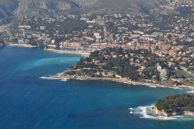
Cassis is a picturesque town a little over 1 and 1/2 hours from Sablet snuggled at the bottom of a steep bowl of land along the Mediterranean Sea between calanques (little coastal fjords with tall cliffs), about 25 km east of Marseille.

Cassis is on a steep hillside with vineyards and pastel-colored houses that tumble down to a seaside port lined with more pastel-colored houses, shops and restaurants with 8,000 inhabitants.

The area where Cassis now sits was first occupied between 500 and 600 BC by people from Liguria, a region of north-western Italy, who built a fortified habitation at the top of Baou Redon. These people lived by fishing, hunting, and farming.

If you go, I recommend you try to get to Cassis early in the morning since parking is often a challenge. From time to time, we have to park in a remote lot (Relais des Gourgettes) and hike or ride the navette (shuttle bus) to the port.

Port area where Quai des Baux and Quai Saint-Pierre meet

Cassis remains a small fishing port but the fishing boats now share the harbor with yachts and a collection of boats that tourists can book for visits to the nearby calanques. You will see traditional wooden fishing boats known as pointus tied up along the Quai des Baux.

Pointus, traditional wooden fishing boats tied up along Quai des Baux

The port is lined with tourist shops, terrace cafés and restaurants which offer a variety of food and prices. It's always great fun to watch people stroll down Quai des Baux while you soak up the sun in front of one of the cafes that line the port.

Restaurants along Quai des Baux

The fishermen sell their morning's catch quayside on tables near their boats. The selection changes daily as choice is selon arrivage (dependent on what they catch) that day.

Fisherman selling his morning catch quayside on the Quai des Baux

Over the years, many artists and writers have been attracted to Cassis. Frédéric Mistral, the Nobel Prize-winning author and defender of Provençal language and traditions, took a great fancy to Cassis, even though he was not a native of the town.

The writer famously declared, in Provençal, "Qu'a vist Paris, se noun a vist Cassis, pou dire, ‘n'ai rèn vist'." "He who has seen Paris but not Cassis can say, ‘I haven't seen anything'."

Cassis harbor

The Mediterranean coast near Cassis is known for the calanques ("fjords"), a series of white limestone rocks scored through with deep valleys that extend for almost 20 km (12.4 miles) along the Mediterranean between Cassis and Marseille.

A fun activity for Cassis visitors is a boat trip out to the calanques. There is a kiosk on Quai Saint-Pierre that sells tickets for all the charter boats that line the Cassis port for trips out to 3, 7 or 13 calanques. It takes about 45-minutes for a boat tour out and back to see 3 of the closest calanques.

Port Miou seen in the picture below is the closest calanques and easiest to reach from the center of Cassis. The Romans used Port Miou as a harbor. In fact, its name comes from the Latin portus melior: the best port. It's the deepest and most sheltered of the calanques between Cassis and Marseille.

The calanque of Port-Miou

Port Pin is the smallest and most intimate of the three calanques of Cassis. It is surrounded by Aleppo pine trees typical of this part of the Mediterranean.

The calanque of Port-Pin with its sandy beach surrounded by Pine trees

Port Pin boasts a small sand and shingle beach and the water here - emerald or turquoise depending on the light - is very clear and perfect for swimming.

A tourist boat leaving the calanque of Port-Pin

Limestone rock formation at the entrance to one of the calanques

En Vau is the most spectacular of the three calanques closest to Cassis and also the most difficult to get to. Extremely steep, it's popular with rock-climbers, there is a little shingle beach.

Entrance to En Vau calanque

Entrance to Cassis harbor

There are four public beach areas in Cassis. The Grand Mer beach is the main beach near the center of town and consists of sand and pebbles.

Cafes and houses along Quai Jean Jacques Barthélémy

Besides its stunning location and the calanques, Cassis is also famous for its wine. When you exit off the A50 auto route, the road down to Cassis is a winding road that goes past vineyards planted on steep hills between olive groves and country houses above Cassis.

The wineries of Cassis produce red, white and rosé wines but it's the white wines for which the appellation is best known. We like Cassis white and rosé wines a lot.

By the way, don't confuse the wines of Cassis with crème de cassis, a sweet black currant liqueur, a specialty of Burgundy which takes its name from black currants (cassis), not this town.


We have visited Cassis many times but never drove the route des Crêtes. So when Shirley and I went to Cassis last fall, we decided to drive to La Ciotat by way of the route des Crêtes and go back to Sablet that way.

The route des Crêtes (a generic term meaning "road across the crests"), is a 15 km (9 miles) stretch of road, that takes you between Cassis and La Ciotat, with 360 degree views over some of the most superb scenery in Provence along the way.

The route des Crêtes is closed to traffic (and hikers) on days of very strong wind and/or when fire risk is high. There are road signs as you approach it from Cassis and La Ciotat that will let you know if the road is open.

On the route des Crêtes between Cassis and La Ciotat

If you have comments or questions about Cassis, or elsewhere in Provence, please leave your comments below or send me an email at my address below.

If you are thinking about a trip to the South of France including spending time in Provence, we invite you to visit our website. Our house is available for rent by the week or more. We still have some weeks open in April, June, and August. You can reach us for further information by sending an email to chcmichel@aol.com.

Saturday, February 22, 2020

Tuesday morning at the Vaison-la-Romaine weekly market, our favorite time in the week

We plan our days in Sablet around the Tuesday morning market in Vaison-la-Romaine. Tuesday mornings, rain or shine, always finds us leaving the house early for the trip to Vaison-la-Romaine.

If you don't know, Vaison-la-Romaine is a quick 6 mile trip down a winding road and then left around the round-about across the Ouvèze River. Vaison-la-Romaine is divided by the Ouvèze River into two parts; on the left bank is the old medieval town with the Castle of the Counts of Toulouse at the highest point shown in the photograph below and on the right bank is the ancient Roman colony and modern town.

We try to get to the market shortly after 8:30 in the morning. Yes, I know it is early to be out and about while you are on vacation. But take my advice, it will be much easier to find parking. By 10:00, it will be difficult to find any parking, let alone a convenient spot close to the market area.

Also, by 10:00, the streets will be crowded with people trying to make their way through the market and it's not so much fun in my opinion. So we get through the market and retire to one of the Cafés that line Place Montfort for a petit Café, hopefully with friends.

Vaison-la-Romaine medieval upper town

After we park, usually near Notre-Dame-de-Nazareth Cathedral, we walk along the north side of the Cathedral past a very large field of Roman ruins which border the path to the main market area. I am embarrassed to say we don't give much more thought to these ruins as we walk pass them than we do to walking past houses in our California neighborhood.

Path to market area along La Villasse ruins

What makes these Roman ruins unique in my opinion is that they are ruins of a village with streets and shops and houses, rather than individual ruins like the Arena in Nîmes or at the Pont du Gard, the Roman aqueduct bridge built in the first century AD, so you get a sense of the overall layout of the town.

La Villasse

The Roman ruins in Vaison-la-Romaine are spread over two sites; Puymin adjacent to the Office of Tourism with its Musée Théo Desplans (museum) and Théâtre Antique (Roman theater) built in the first century AD and La Villasse which we pass on our walk up to the market.

These are ruins of shops along the central street of La Villasse. The Romans were very practical and built one street for chariots and a parallel footpath for pedestrians covered by a portico (many of the columns remain in place) to shelter the stalls and people from the sun and bad weather.

La Villasse

Public bath in La Villasse


One of the best things about owning or renting a house in Provence, in my opinion, is the chance to cook some of the amazing produce, seafood, cheese and meats you find at the various weekly markets as you travel around Provence. And let me tell you, the weekly market in Vaison-la-Romaine is one of the biggest and best.

By contrast when you stay in a hotel or similar accommodation, you will walk through markets, and look, sniff and drool about the possibilities that lie before you on those artfully displayed tables. You will undoubtedly buy a few things for a snack or picnic, but you won't experience the satisfaction that comes from eating a home-cooked meal on your terrace with ingredients bought at that's morning market.

Cours Taulignan in Vaison-la-Romaine

The weekly market is a kaleidoscope of colors and smells of Provence with up to 450 vendors in the summer (pottery, arts and crafts, food stalls of all kinds, local fruits and vegetables, linens, soap, regional specialties, clothing) and spreads out over Place Montfort, the main square in the center of town and nearby streets.

Most of the fish, meat, cheese, fruit and vegetable sellers set up their stands on Cours Taulignan or on one of the cross streets. The market is an ancient tradition dating all the way back to 1483.

The photographs which follow show a few of the offerings on display when we were at the market last fall. To confirm the obvious, the offerings at the market change from season to season, ensuring that you have the freshest and most seasonal ingredients to cook.

Garlic strings from the Tarn

There are several vendors selling olives and tapenades

Even though it was October, we were able to find some nice fresh, tasty tomatoes, that were the base for several salads during our sejour in Sablet.

Last of the season's tomatoes

Olive oils and tapenades

Fresh Cèpes, Porcinis or by whatever name you call them are delicious. Don't touch!

Other varieties of mushrooms

Figs and prunes

Fennel, Eggplants and Peppers

Several cheese vendors set up shop at the market every week. Full disclosure, I don't buy from any of them since I am partial to the cheese that Josiane Deal sells at her wonderful shop called Lou Canesteou just a few steps away on Rue Raspail off Place Montfort, the town's main square.

Freshly-made artisan cheese

Our favorite fishmonger. He also comes to Sablet on Friday mornings

There are a number of butchers you can check out

You have to have spices for cooking. In Provence, spices are not sold in the market in little jars or packages. Buy only what you are going to use for a week or two as there is no reason to use stale spices since you don't have to buy a jar which might last 6 months or more.

Spices are displayed, uncovered, on tables like these and sold in sachets based on how much you want

There are olive groves every where so it is not surprising that there are kitchen utensils and dishes made from olive wood for sale in the market.

Utensils made from olive wood

Hand painted images of the Provence countryside. If you have been to our house, you will probably recognize the artist.

If you want to learn to cook some typical Provençal dishes from seasonal ingredients at the market, I recommend you contact our friend Barbara. Barbara is a contemporary art critic turned chef/cooking instructor at Cuisine de Provence cooking school she runs out of her beautiful home in Vaison-la-Romaine. Quite a few of our guests have taken classes and so have I and she is recommended in Rick Steves' guide to "Provence and the French Riviera".

If you have comments or questions about Vaison-la-Romaine, or elsewhere in Provence, please leave your comments below or send me an email at my address below.

If you are thinking about a trip to the South of France including spending time in Provence, we invite you to visit our website. Our house is available for rent by the week or more. We still have some weeks open in April, June, last part of July and August. You can reach us for further information by sending an email to chcmichel@aol.com.

Sunday, February 16, 2020

We live on Grande Rue in Sablet in the Provence Region of France

I have always found it very amusing that the street where our house in Sablet is located is called "Grande Rue". Read on to find out why this is so perplexing to me.

For those of you who don't know, Sablet is a small village (population 1284) located at the base of the jagged Dentelles de Montmirail west of Mont Ventoux in the Vaucluse region of Provence, France. The village sits on a hill near the Ouvèze River.

Sign at entrance to Sablet

Sablet is known for the Côtes du Rhône Villages wines produced by village winemakers. The vineyards were first cultivated by the Counts of Toulouse, to whom the area then belonged. During the 14th century, the vineyards became papal possessions when the papacy moved to Avignon. Sablet was awarded AOC of "Côtes du Rhône Villages Sablet" in 1974.

Sablet

Although the first fortifications of the village were most likely built in the 9th century to ward off attacks by the Saracens, construction on the walls didn't start until the 15th century. These ramparts have recently been restored by the Association des Compagnons des Barrys.

Sablet ramparts and tower

Sablet is filled with charming and picturesque shaded streets adorned with flowers, passageways with exposed beams, and fountains. Stone houses line narrow streets that curl in concentric circles around a beehive shaped hill up to St. Nazaire Church (12th century). St. Nazaire’s bell tower is the highest point in the village.

Our house at intersection of Rue d'Eglise and Grande Rue

Streets were named to reflect the activities of the village residents over the centuries such as climbing the "Escaliers de l'Eglise" to St. Nazaire Church or visiting the shoemaker on "Rue du Cordonnier". Not sure what they were thinking, when they named our street "Grande Rue". In French, "Grande" normally refers to something big, which Grande Rue where our house is located, is definitely not.

Me driving on Grande Rue

One of our favorite pastimes is to watch drivers, usually tourists, struggle to make the left turn from Grande Rue onto Rue d'Église just before our house to go up the hill to Saint Nazaire Church. You can't do it without a partial turn, then back up, then proceed forward up the hill. Only locals make the turn on the first attempt. We also chat with passersby, especially when we hear English being spoken.

Shirley hanging out the kitchen window overlooking the intersection of Grande Rue and Rue de l'Eglise

An interesting thing we have learned is the wine cave under our house was connected to caves under neighboring homes through a network of tunnels that ran under the streets. The locals would travel to their neighbors through the tunnels rather than on the street. The entrance to the network of tunnels was near the fountain and lavoir at Place Yvan Audouard.

Covered passageway on Grande Rue

Shirley stands in "Grande Rue" and stretches her arms between our house and the house across the street. You don't have to worry about traffic as not too many vehicles pass our front door besides the one belonging to the post office.

Shirley can almost touch both sides of Grande Rue

If you have come to visit us in Sablet, you have figured out that one of my favorite places for taking pictures of people in Sablet, is around the pretty fountain at Place Yvan Audouard, just a few steps from our house on Grande Rue.

A favorite place to take pictures is the fountain a few steps from our house

If you have comments or questions about Sablet, or elsewhere in Provence, please leave your comments below or send me an email at my address below.

If you are thinking about a trip to the South of France including spending time in Provence, we invite you to visit our website. Our house is available for rent by the week or more. We still have some weeks open in April, June, last part of July and August. You can reach us for further information by sending an email to chcmichel@aol.com.