Showing posts with label Roman Aqueduct. Show all posts

Friday, September 24, 2021

A Little Family Mystery about Le Barroux Resolved

Who doesn't love a good family mystery? 

My father Daniel Augsburger was born in Switzerland. His mother was French and at a young age, the family moved to the South of France. He came to the United States in 1939, just prior to World War II for college and pursue graduate degrees at the University of Michigan. 

Long story short, he never returned to live in France, met my mother Joyce at the University of Michigan and was offered an opportunity to teach, first at the University of Michigan then at Emmanuel Missionary College, now Andrews University in Berrien Spring, Michigan.

I was lucky over the years that I was able to travel with my parents along with sister Lydie and brother Dan as money permitted to visit his family living in France and Switzerland. I also got to live for one year in Strasbourg, France while he was on a study sabbatical. So we got to know our aunt's, uncles, cousins and other extended family members quite well.

I have looked at dad's Kodak slides and picture albums that record our trips to France and Switzerland many times over the years. A few years ago, my brother sent me CDs with pictures my father or someone else had taken of he and his family and some of he and mom at their wedding near Geneva, Switzerland. 

I learned from cousins back in 2014 that our grandfather had owned a house in Le Barroux, France. I am not sure if I ever saw the picture below before we bought our house in Sablet but it immediately caught my eye when I saw it on the CD because it showed it was in a town called Le Barroux. 


Image of Road Sign and House found on Augsburger CD

If I had seen the picture before, it wouldn't have meant anything to me because Le Barroux could have been anywhere in France or French-speaking Switzerland as far as I was concerned. However, since we have gotten to know the area around Sablet, I know Le Barroux is a small village (population 629 in 2017) set on a hill topped by a large 12th century castle just 13 miles from Sablet. 

Le Barroux Castle

We come to Le Barroux from time to time to hike around the village and to visit Sainte Madeleine du Barroux Abbey located outside of town. We also come to buy locally grown saffron as I told you about here. So when I saw the picture on the CD I was excited to confirm that my grandfather owned a house so close to our village and I like to think that my father probably spent time in the area. 

Sainte Madeleine du Barroux

The Le Barroux castle was built to oppose Saracen and Italian incursions and went through major rebuilding in the 16th and 17th centuries. The castle was damaged during the French revolution, was repaired in 1929 with private funds, set on fire by German occupation forces in 1944 as reprisal for acts of resistance, and restored again in 1960.

Le Barroux Castle

After failing to find the house when we first tried in 2014, I was eager to try again with the picture of the road sign from the CD as my guide to the property. So on October 6, 2018, with my cousins Jean Marc and Christine in tow, we headed off for Le Barroux to find the house or what was left of it. 

We arrived in Le Barroux and parked in the center of the village. We confidently walked up to the first person we encountered, a man walking on the street, who confirmed he lived in Le Barroux so told him what we were doing and showed him our picture. 

We were disappointed when he said he didn't know the village that well and these roads nor house looked familiar to him. He suggested we go see a lady who lived close by that he knew walks all over Le Barroux, maybe she would know where the house was located?

We knocked on her door and she opened. We explained to her what we were trying to find and why and showed her my picture. Turns out, she was born in the same town in Switzerland as my dad. She said she had an idea where these roads crossed and invited us in. She led us to her computer and pulled up maps of the area and pointed out where she thought it was and gave us some general directions.

We figured out if she was right that the house was out in the direction of the saffron farm we had previously visited. After a couple of wrong turns and ending up on a very little road, we found the sign for Chemin Aqueduc and Chemin De Bois Long. As I said it was a very little road and more like a path which is in fact the English translation for "chemin".

Matching Road Sign

From the junction where we stopped we could see a house that matched the one in the picture on the CD. Backed up to a forested area and vineyards all the way around the rest of the property, we could imagine why the property appealed to my grandfather. No one was around and it was hard to tell if the property was still inhabited or not.  

Le Barroux House


Le Barroux House

While we were standing there chatting about the area and house, a car drove up, it was our new Swiss friend from Le Barroux who had driven out to see if she was right about the location of the roads. 

Happy Cousins with Le Barroux House in Distance

This past July 27, Shirley and I drove to Le Barroux to see if we could find the property again. Shirley was quite sure she could, I didn't really have a clue besides being near L'Aube Safran. Thankfully, Shirley was right, she says women are better with directions because they have uterus homing device to find things.

One of the crossroads is called "Chemin Aqueduct" so I assumed that if we followed the path we might find an old aqueduct. Sure enough, after a walk down a dirt path off the main "Chemin Aqueduc" path, we found the remains of an aqueduct. 

Le Barroux Aqueduct

This was the remainder of an aqueduct built around 1840 by the Commune of Le Barroux. Le Barroux lacked water and the Commune built a 4 km long canal and this aqueduct to bring water from a spring near St Andeol. Only one arch remains, the aqueduct is unusual in that the canal rests on a circle rather than pillars. 

Le Barroux Aqueduct

I am happy this mystery is solved. I hope to find some family member who can tell me when grandfather bought the property, if there was a particular reason why he bought here and how long he owned it. I would love to know for sure if dad spent time at this house. I assume yes since he had this photograph in his very large collection of family pictures.

If you are thinking about a trip to the South of France including spending time in Provence, we invite you to visit our website. Our house is available for rent by the week or more. We still have weeks open in November and through the end of the year and in 2022 and beyond. You can reach me for further information by sending an email to chcmichel@aol.com. 

Saturday, March 7, 2020

Go visit the Pont du Gard if for no other reason, this "masterpiece" has been standing for 2000 years!

Our favorite Roman ruin in the South of France is the Pont du Gard, the aqueduct bridge that crosses the Gardon River about 60 km (37 miles) from our house in Sablet, between the towns of Remoulins and Uzès.

The Pont du Gard is part of a 50 km (31 mile) aqueduct constructed by the Romans in the middle of the 1st century to bring fresh water from the Eure spring near Uzès, to the Roman city of Nîmes where it supplied running water to fountains, baths and private homes around the city.

The Pont du Gard has three tiers of arches; It is 274 meters (899 ft) in length and stands at a height of 48.8 m (160 ft). Its width varies from 9 m (30 ft) at the bottom to 3 m (9.8 ft) at the top. The three levels of arches are recessed, with the main piers in line one above another.

As you walk out to the Pont du Gard, look for the ancient olive trees on the Left Bank along the path from the Visitor Center. The plaque by one of the trees says it was born in 908 and lived in Spain till 1985 when the Counsel General of the Gard adopted the tree and planted it here in 1988.

1,000 year old Olive tree near the Pont du Gard

Make sure you check out the construction of the bridge, take in the view up or down the river valley, wander across to the far side, explore down along the river and climb up the steps to the upper trail where you have great views of the bridge and surrounding area.

Pont du Gard

The Pont du Gard was constructed largely without the use of mortar or clamps. Most of the stones were extracted from the Estel quarry located approximately 700 meters (2,300 ft) downstream, on the banks of the Gardon River. The stones were cut to fit perfectly together by friction and gravity, eliminating the need for mortar.

The builders left inscriptions on the stonework conveying various messages and instructions. Many blocks were numbered and inscribed with the required locations, such as fronte dextra or fronte sinistra (front right or front left), to guide the builders

Underside of Pont du Gard archway with Roman Numeral placement markings

Shirley at Pont du Gard

The straight-line distance from the spring near Uzès to the town of Nîmes is only about 20 km (12 mi), but the mostly underground aqueduct was built along a winding route measuring around 50 km (31 mi) to circumvent the southernmost foothills of the Massif Central, known as the Garrigues de Nîmes. This was the only practical way to transport water from the spring to the town.

Pont du Gard from right bank of Gardon River

The Romans needed a way to get the water that would flow through the aqueduct across the Gardon River so they built the Pont du Gard with a water channel to complete the aqueduct and get water to its destination in Nîmes.

A view of the Pont du Gard from the left bank of the Gardon River

It is estimated that the aqueduct supplied Nîmes with around 40,000 cubic meters (8,800,000 imp gal) of water a day that took nearly 27 hours to flow from the spring to the town.

A view of the water channel at the top of the Pont du Gard from the left bank of the Gardon River

As I noted earlier, the Pont du Gard was built to carry water from the aqueduct across the Gardon River. Several of the River's tributaries are also called Gardon. The Gardon River rises in the Cévennes mountain range and flows for 133 km into the Rhône River at Beaucaire, from where it flows into the Mediterranean Sea.

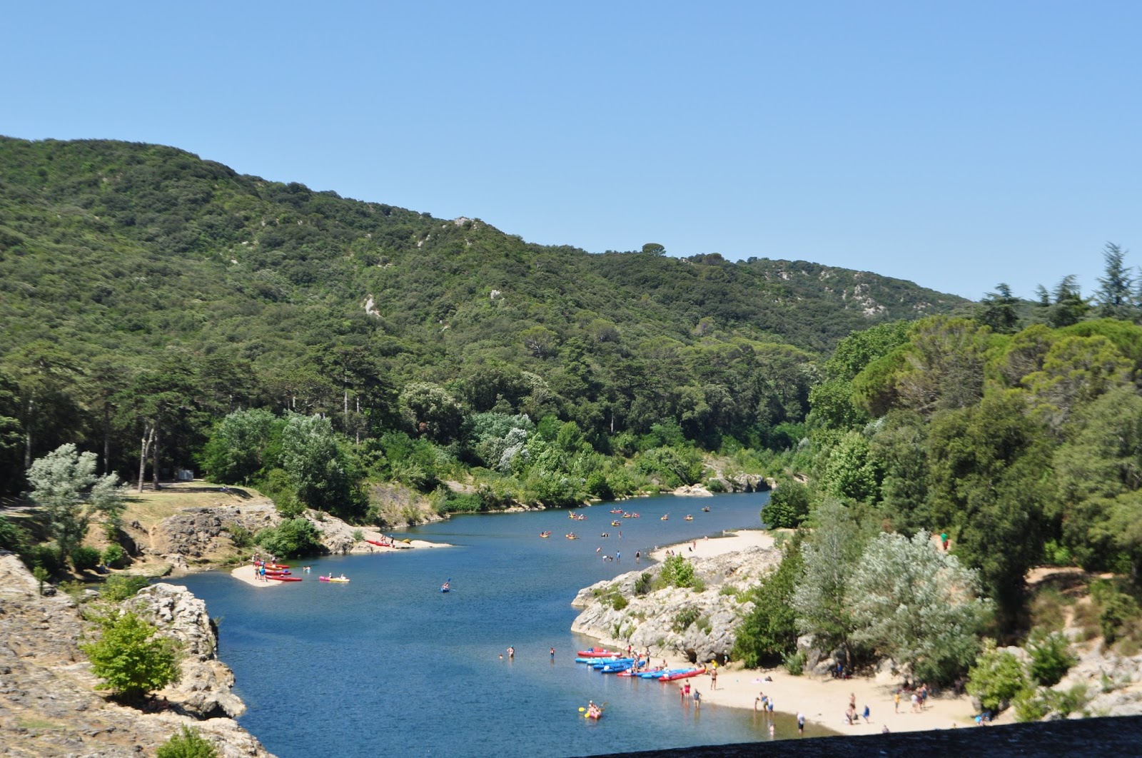
View of the Gardon River towards Uzès from Pont du Gard

The Pont du Gard is one of the most popular tourist attractions in France and is open all year round, though the restaurant and some indoor areas close for part of the winter. You can stay there after dark (exact closing times vary depending on the season), when the bridge is illuminated in summer.

As I told you here, a fun way to view the Pont du Gard is from a canoe or kayak on the Gardon River on a hot summer day. There are several companies around Collias that will rent canoes and provide transportation to your point of departure and from your point of arrival.

The Pont du Gard was added to UNESCO's list of World Heritage sites in 1985. The description on the list states: "The Roman architects and hydraulic engineers who designed this bridge created a technical as well as an artistic masterpiece."

Shirley and friends in front of Pont du Gard

When we go, we park in the lot on the Rive Gauche (Left Bank) which is the main entry and parking lot. The main visitor center is on this side, where you walk through to access the Pont du Gard. There is a small charge for parking and they have recently instituted a fee for visiting the Pont du Gard.

The visitors' center is where the ticket machines and information center are located. Here too are restrooms, snack bar, souvenir shops, book store and audio-guides for your visit (available in several languages).

If you have comments or questions about the Pont du Gard, or elsewhere in Provence, please leave your comments below or send me an email at my address below.

If you are thinking about a trip to the South of France including spending time in Provence, we invite you to visit our website. Our house is available for rent by the week or more. We still have some weeks open in April, June, and August. You can reach us for further information by sending an email to chcmichel@aol.com.

Wednesday, August 23, 2017

A visit with friends to the amazing Roman Pont du Gard

Our favorite Roman ruin in the South of France is the Pont du Gard, the aqueduct bridge that crosses the Gardon River in the Gard Department of Languedoc-Roussillon about 60 km (37 miles) from our home in Sablet, between Remoulins and Uzès.

The Pont du Gard is part of the 50 km (31 mile) Nîmes aqueduct constructed by the Romans in the 1st century between 41 and 54 AD to bring fresh water from a spring near Uzès, the Fontaine d'Eure, to the Roman city of Nîmes where it was distributed to fountains, baths and private homes around the city.

When we go, we park in the lot on the Rive Gauche - Left Bank which is the main entry and parking lot. The main visitor center is on this side, where you walk through to access the Pont du Gard. There is a small charge for parking and they have recently instituted a fee for visiting the Pont du Gard.

The visitors' center is where the ticket machines and information center are located. Here too are restrooms, snack bar, souvenir shops, book store and audio-guides for your visit (available in several languages).

It is a short walk from the visitors' center to the Pont du Gard. If you go, make sure you check out the construction, enjoy the view up or down the river valley, wander across to the far side, explore down along the river and climb up the steps to the upper trail where you have great views of the bridge and surrounding area.

View of Pont du Gard as you arrive from Visitor's Center

As you walk out to the Pont du Gard, make sure to look for the ancient olive tree on the Rive Gauche - Left Bank along the path to the Pont du Gard from the Visitor Center. The sign by the tree says it was born in 908 and lived in Spain till 1985 when the Counsel General of the Gard adopted the tree and planted it here in 1988

Ancient olive tree along path to Pont du Gard from Left Bank Visitor's Center

The Gardon River seen below gives its name to the Gard Department. Several of its tributaries are also called Gardon. The Gardon is 133 km long and flows into the Rhône River at Beaucaire, from where it flows into the Mediterranean Sea.

View south down the Gardon River from Pont du Gard

After the Roman Empire collapsed and the aqueduct fell into disuse, the Pont du Gard remained largely intact, due to the importance of its secondary function, as a toll bridge. For centuries the local lords and bishops were responsible for its upkeep, in exchange for the right to levy tolls on travelers crossing the river.

Pedestrian roadway at the base of the Pont du Gard

The Pont du Gard was built of soft-yellow limestone blocks taken from nearby Estel quarry that borders the Gardon river's left bank and assembled largely without mortar or clamps. The stones, some of which weigh up to 6 tons, were cut to perfectly fit together eliminating the need for mortar. The cut stone was lifted into place with a human-powered treadmill providing the power for the winch.

Pont du Gard from the upper trail

The straight-line distance between Nîmes and the water source is only about 20 km (12 mi). However due to uneven terrain, the mostly underground aqueduct takes a long, winding route measuring around 50 km (31 mi). The Romans had to build a bridge with a channel to allow water to flow across the Gardon River to successfully complete the aqueduct.

Channel on top of Pont du Gard that carried water across the Gardon River

The Aqueduct of Nîmes had the capacity to carry 35,000 cubic meters of water a day from the spring which was the source of fresh water for the city of Nîmes. It took nearly 27 hours for the water to get from the spring to Nîmes.

Some sections of the channel are tunneled through solid rock as you can see below. In all, 35 km (22 mi) of the aqueduct was constructed below the ground.

The entrance to the underground channel after the water crossed the Pont du Gard

The Pont du Gard has three tiers of arches; the bottom row has 6 arches of 22 m (72 ft) height; the middle row has 11 arches 20 m (66 ft) height; and the upper row has 35 (originally 47) arches of 7 m (23 ft) height. The width of the bridge varies from 9 m (30 ft) at the bottom to 3 m (9.8 ft) at the top. It has a length of 274 m (899 ft) and stands at a height of 48.8 m (160 ft).

View of Pont du Gard from upper trail

As I told you here, an excellent way to view the Pont du Gard from a completely different perspective is from a canoe on the Gardon River on a hot summer day. There are several canoe companies around Collias that will provide shuttle transport to your point of departure and from your point of arrival.

Shirley and neighbors at the Pont du Gard

The Pont du Gard is open all year round, though the restaurant and some indoor areas close for part of the winter. You can stay there after dark (exact closing times vary depending on the season), when the bridge is illuminated in summer.

View north up the Gardon River from the Pont du Gard with the 19th century watermill in the distance

Despite having been to the Pont du Gard quite a few times, Shirley and I are amazed anew each time by the sheer size of the bridge and how the Romans were able to design and build it without much more than math and manpower. It is believed to have taken about fifteen years to build, employing between 800 and 1,000 workers.

If you are in the area, we think this is one of the sites you must visit. Let us know what you think.

Sunday, September 25, 2016

A Visit to Historic Pont du Gard

With daughter Tricia and family visiting, we planned activities that would interest grandchildren Avery and Caedon and frankly use up their seemingly boundless energy including hiking and swimming as often as we could. We figured a visit to Pont du Gard would be perfect.

Our favorite Roman ruin in the South of France is the Pont du Gard, the aqueduct bridge located in the Gard Department of Languedoc-Roussillon about 60 km (37 miles) from our home in Sablet, between Remoulins and Uzès.

The Pont du Gard is part of the 50 km (31 mile) Nîmes aqueduct constructed by the Romans in the 1st century between 41 and 54 AD to bring water from a spring near Uzès, the Fontaine d'Eure, to the Roman city of Nîmes where it was distributed to fountains, baths and private homes around the city.

On our most recent visit with daughter Tricia and family, we parked in the lot on the Rive Gauche - Left Bank, there is a small charge for parking but access to the bridge is free, and strolled along the path until the Pont du Gard came into view.

View of Pont du Gard as you arrive from Visitor's Center

The 900 foot long Pont du Gard has three levels of arches: six crossing the Gardon River, 11 in the middle tier and 35 smaller arches at the top which support the water channel. The Pont du Gard is 161 feet high above the Gardon river.

Stonework on the Pont du Gard, showing the protruding blocks that were used to support the scaffolding

You can walk across the bottom tier which has been used as a thoroughfare for centuries - in 1285 the bishop of Uzès ordered that a toll be collected from all travelers crossing the bridge.

Shirley and grandchildren Caedon and Avery

The Pont du Gard was built of limestone from nearby Estel quarry that borders the Gardon river's left bank and assembled largely without mortar or clamps. The stones, some of which weigh up to 6 tons, were cut to perfectly fit together eliminating the need for mortar. The cut stone was lifted into place with a human-powered treadmill providing the power for the winch.

View of Pont du Gard from upper trail

Shirley and I always look at the arches and admire the skill it took to design the Pont du Gard without computers and imagine the thankless labor of soldiers, craftsmen and slaves who built the bridge almost 2000 years ago without cranes or other equipment.

Swimmers along the Gardon River near the Pont du Gard

The Aqueduct of Nîmes had a capacity to carry 35,000 cubic meters of water a day that took nearly 27 hours to flow from the spring to Nîmes. The aqueduct descends in height by only 17 m (56 feet) over its entire 50 km (31 mile) length, an indication of the precision the Roman engineers were able to achieve using rudimentary technology.

View south down the Gardon River from the upper trail near Pont du Gard

Bringing water from the spring near Uzès to Nîmes was easier said than done. Although the distance between the spring and the city is only 20 km (12 miles) in a straight line, the Romans built the aqueduct 50 km (31 miles) mostly underground in a long, winding route to cross or circle the natural obstacles of the countryside.

Side view of the Pont du Gard showing the three levels of arches

The Pont du Gard carried water in the channel seen below across the gorge of the Gardon River.

Channel on top of Pont du Gard that carried water across the Gardon River

The Pont du Gard is remarkably well preserved and was added to UNESCO's list of World Heritage Sites in 1985.

View of the Pont du Gard from the Right Bank of the Gardon River

The Pont du Gard can be accessed from either the right bank or left bank of the Gardon River. There are several places where you can swim in the river if you so choose.

Another view south of the Gardon River from the Pont du Gard

I remember visits to the Pont du Gard when I was very young, probably in connection with visits to my grandmother's family who lived near Anduze in the Gard Department, and swimming in the Gardon River near the Pont du Gard.

View south down Gardon River from Pont du Gard

View north up the Gardon River from Pont du Gard

Make sure to look at the ancient olive tree on the Rive Gauche - Left Bank on the path to the Pont du Gard from the Visitor Center. The sign by the tree says it was born in 908 and lived in Spain till 1985 when the Counsel General of the Gard adopted the tree and planted it here in 1988.

Ancient olive tree along path to Pont du Gard from Left Bank Visitor's Center

A good way to explore the Pont du Gard is as part of a visit to nearby Duchy of Uzès which is worthwhile. There is a wonderful Marché Provencal in Uzès on Saturday mornings, one of our favorite markets after the Tuesday morning market in Vaison la Romaine.

With our grandchildren visiting, we didn't go to Uzes but rather after grabbing snacks at the Visitor's Center, we headed to Collias France to get canoes to go up the Gardon River under the Pont du Gard. Check back to see my next post where I share pictures of our visit to Pont du Gard by canoe.